LiDAR Systems

Cutting-Edge Lidar based sensors and Mobile Mapping Solutions.

Lidar 3D Sensors

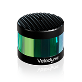
Velodyne LiDAR –the market leader in Lidar technology provides a full line of Lidar sensors capable of delivering the most accurate real time 3D data on the market.

The real-time LiDAR sensor technology is being used in a variety of commercial applications including autonomous vehicles, vehicle safety systems, 3D mobile mapping, 3D aerial mapping and security.

Veoldyne’s product line of high quality Lidar sensors includes the PUCK Hi-Res, PUCK LITE™, PUCK™ (VLP-16), the HDL-32E and  HDL-64E.

Mobile Mapping Solutions

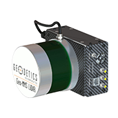
Combining Lidar with GPS and IMU sensors- our mobile mapping solutions are fully integrated LiDAR mapping payloads that are the ultimate fit for small unmanned vehicles (UAVs). These precise Positioning, Navigation and Timing (PNT) solutions are designed to address a wide range of demanding requirements for air, sea and land, including high speed pointing/attitude and relative position/angle applications.

Compatible Software products- including software toolbox, visualization and analysis tools specially developed to help you handle your resulting PNT data easily and quickly.

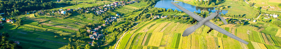
Applications are as diverse as the platforms using this information ranging from PNT for stationary or slowly moving platforms such as Aerostats to PNT for high-dynamic aircraft and everything in between.

Our leading mobile mapping solutions include the Geodetics Geo-MMS and the Routescene LidarPod®.

For more information please review our products and solutions below or go to:

Lidar 3D Sensors

Mobile Mapping Solutions 


Quotation Request

Velarray H800

Precise Long-Range Vision for ADAS and Autonomy.

The optimal solid state lidar sensor for ADAS and autonomous applications.

The H800’s long-range combined with a wide horizontal FOV detects objects early enough to enable safe stopping distances in urban driving scenarios and collision avoidance on curves and turns.


  • Solid state lidar
  • Perception data at a range of 0.1 m to 200 m supporting safe stopping distances at highway speeds
  • Configurable frame rate and resolution
  • Advances driver assistance features including Automatic Emergency Braking and Lane Keeping Assist
  • Compact, embeddable form factor for seamless interior/exterior integration
  • Specifically designed for automotive grade performance
  • Built using Velodyne’s breakthrough micro-lidar array (MLA) architecture, a robust and reliable design for mass production

Velabit

Compact, Embeddable, Affordable.

The next generation Velabit, Velodyne’s smallest sensor, brings new levels of

versatility and affordability to 3D lidar perception including a dramatic improvement in field of view. Can be embedded almost anywhere within vehicles, robots, UAVs, infrastructure and more. An optimal solution for ADAS and autonomous vehicles, enabling robust perception coverage for Blind-Spot Monitoring, Cross Traffic Detection, and Automatic Emergency Braking.

  • Dimensions: 2.4” x 2.4” x 1.4”
  • Range up to 100m
  • 90° HFoV x 70° VFoV
  • Highly configurable
  • Proven, Class 1 eye-safe 903 nm technology
  • Bottom connector, with cable length options
  • Multiple manufacturing sources available for qualified production projects

Velarray M1600

Precise Near-Field Vision for Autonomy.

Designed for autonomous applications in sidewalk, commercial and industrial

settings, the Velarray M1600 provides outstanding near-field perception for safe navigation in diverse environmental conditions.


  • Solid state lidar
  • Proven eye-safe technology
  • 905 nm wavelength
  • IP67
  • 0.1 m to 30 m range
  • Configurable frame rate and resolution
  • Indoor/outdoor and day/night performance
  • Functional Safety Compliant
VLS-128

ALPHA PRIME VLS-128

The optimal long-range sensor for autonomous mobility with unrivaled combination of field-of-view, range, and image clarity. This state-of-the-art sensor generates high quality perception in a wide variety of light conditions, with advanced sensor-to-sensor interference mitigation, power efficiency, and thermal performance. Providing long-range detection of low reflectance objects, the Alpha Prime enables autonomous operation within a broad range of settings, including urban and highway environments.

key Features:

  • Best horizontal (360°) and vertical (40°) long-range sensor
    • 10% targets >220m typical
    • 5% targets >150m typical
    • Ground plane hits >90m typical
  • High resolution (0.2° x 0.1°) and point density at full frame rate
  •  Industry-leading, proprietary sensor-to-sensor interference mitigation
  •  Strong performance with retro reflectors & sunlight
  •  New power efficiencies for maximum operating temperature
  •  Proven, Class 1 eye-safe 903 nm technology
  •  Bottom connector, with cable length options
VLP-32

Ultra Puck (VLP-32C)

ULTRA Puck™ VLP-32C is the newest long-range LiDAR sensor in Velodyne’s product portfolio that combines best-in-class performance with a small form factor. A high-resolution LiDAR sensor that is cost- effective when compared to similar performance sensors but developed with automotive applications in mind to ensure reliability while delivering the performance demanded by the market. The VLP-32C retains the innovative breakthroughs in 3D LiDAR such as 360° surround view along with real-time 3D data that includes distance and calibrated reflectivity measurements along with rotational angles.

Features

  • 32 Channels
  • Dual Returns
  • Up to 200m Range
  • ~600,000 Points per Second
  • +15° to -25° Vertical FOV
  • 360° Horizontal FOV
  • Low Power Consumption
  • Protective Design
  • Connectors: RJ45 / M12

Puck LITE™

Velodyne LiDAR’s Puck LITE™ is a lighter weight version of the VLP-16 PUCK for applications that demand a lower weight to meet their requirements. The Puck LITE™ has identical performance to VLP-16 with the only difference in weight of 590 g vs. 830 g for the latter. No other changes have been made to Puck LITE™ as it retains its patented 360° surround view to capture real-time 3D LiDAR data that includes distance and calibrated reflectivity measurements.

Key Features:

  • 590 grams
  • Dual Returns
  • 16 Channels
  • 100m Range
  • 300,000 Points per Second
  • 360° Horizontal FOV
  • ±15° Vertical FOV
  • Low Power Consumption
  • Protective Design
  • Connectors: RJ45 / M12


PUCK VLP-16

Velodyne’s PUCK™ (VLP-16) sensor is smaller than the VLP-32 and VLP-64 and having new and advanced features. Vastly more cost-effective than similarly priced sensors, and developed with mass production in mind, it retains the key features of Velodyne’s breakthroughs in LiDAR: Real-time, 360°, 3D distance and calibrated reflectivity measurements.

Key Features:

Dual Returns

830 grams

16 Channels

100m Range

300,000 Points per Second

360° Horizontal FOV

± 15° Vertical FOV

Low Power Consumption

Protective Design

Puck Hi-Res™

Expanding on Velodyne LiDAR’s groundbreaking VLP-16 Puck, a 16-channel, real-time 3D LiDAR sensor that weighs just 830 grams, Puck Hi-Res is used in applications that require greater resolution in the captured 3D image. Puck Hi-Res retains the VLP-16 Puck’s 360° horizontal field-of-view (FoV) and 100-meter range, but delivers a 20° vertical FoV for a tighter channel distribution – 1.33° between channels instead of 2.00° – to deliver greater details in the 3D image at longer ranges. This will enable the host system to not only detect, but also better discern, objects at these greater distances.

Key Features:

  • ± 10° Vertical fov
  •  Dual returns
  •  16 Channels
  •  100 m Range
  •  300,000 Points per second
  •  360° Horizontal Fov
  •  Low power consumption
  •  Protective design
  •  Connectors: RJ45  /  M12

HDL-32E

The HDL-32E LiDAR sensor is small, lightweight, ruggedly built and features up to 32 lasers across a 40° vertical field of view. The HDL-32E measures only 5.7″ high x 3.4″ in diameter, weighs less than two kilograms and was designed to exceed the demands of the most challenging real-world autonomous navigation, 3D mobile mapping and other LiDAR applications.

Key Features:

Dual Returns

± 2 cm accuracy

1kg (plus 0.3kg for cabeling)

32 Channels

80m-100m Range

700,000 Points per Second

360° Horizontal FOV

± 40° Vertical FOV

Low Power Consumption

Rugged Design

GEO MMS

Geo – MMS

Geo-MMS is a fully integrated LiDAR mapping payload for integration with small unmanned vehicles. The Geo-MMS includes an inertial navigation system coupled with a LiDAR sensor. Raw data from the integrated GPS, IMU and LiDAR sensors are recorded on the internal data recording device and can be post-processed using Geodetics’ LiDAR tool software package to directly geo-reference the LiDAR point clouds with LAS format output. Geo-MMS is available with a wide range of sensors.

Key Features:

  • Flexible mounting for different platforms including UAV, UAS, ground vehicles and robots
  • Minimized sensor size and weight to meet payload restrictions (5 pounds minimum payload)
  • Available with a many IMU’s to support a wide range of application requirement
  • Centimeter-level position accuracy (dual-frequency RTK configuration)
  • On-board data logging of all raw and navigation solution data
  • User interface to fully control individual and collective GPS, IMU, Laser setting
  • Full post-processing support with GPS/IMU Geo-PostProcessing
  • LAS file output
Point&Pixel

Point&Pixel™ – Combined LiDAR and Photogrammetry

Point&Pixel combines the best of Geodetics’ Geo-Photomap and Geo-MMS LiDAR products by integrating LiDAR point clouds with Photogrammetry and delivering stunning colorized LiDAR point clouds.

Key Features

  • Combines LiDAR and Photogrammetry point clouds
  • Enhances visualization
  • Enables LiDAR point cloud colorization
  • Enhances DTM/DEM extraction
  • Facilitates LiDAR point cloud classification
  • Orthophoto generation in areas Photogrammetry fails (i.e., glaciers, tree canopy, mine site conveyors, etc.)
  • Change detection (2D, 3D, 4D)

LidarPod

The Routescene LidarPod® is cutting edge 3D mapping technology which is transforming the approach to surveys. Your self contained LidarPod® contains an HDL32 LiDAR scanner, a survey grade GPS/INS, data storage and radio telemetry.

Lightweight and compact, the LidarPod can be fitted onto any mobile platform you require. It has been designed specifically for use on UAVs and can also be used on vehicles.

Key Features:

  • saves time, generating more detailed and faster results
  • avoids exposure of personnel to awkward, dangerous and hostile environments
  • reduces time in the field and collects significantly more data compared to conventional survey techniques
  • collates accurate, detailed measurements from the air, which are more difficult to achieve with conventional surveying
  • achieves quicker results by collecting all the data needed in a single pass – much quicker than traditional methods
  • the higher density of data collected provides a much more detailed 3D view
  • collects data from different angles to minimize shadows
  • enables increased visibility in difficult to penetrate terrains such as forests
  • it is portable, lightweight and compact, suitable as flight hand luggage
  • independently CE and FCC certified to ensure compliance with electrical and radio transmission standards

SatLab Apus UAV Lidar based solution

This light compact and superior system integrates an advanced laser scanner with an industrial grade camera and a sophisticated inertial navigation system, is able to collect reliable and great detailed point cloud and rich image information.


Its versatile applications span across 3D spatial data acquisition for terrain mapping, electricity, forestry and agriculture surveys, emergency response, and land planning.

As a robust and intelligent system, Apus excels in most scenes even in the steep, rugged terrain, and thick vegetation.

 Key Features:

  • Data: 1,280,000 points/sec (dual-echo),1,920,000 points/sec (triple-echo)
  • Effective Pixel: 26 Mega Pixel (6252*4168)
  • Lidar Measuring Range:300 m
  • Field of View (FOV):360° (horizontal)*40.3° (vertical)
  • Position Accuracy (pp): Horizontal: 0.01 m; Vertical: 0.02 m
  • Heading Accuracy (pp):0.04°
  • UAVs Designed for DJI M300/DJI M350
  • Lightweight (up to 1Kg)
  • Can capture data autonomously in a designated area
  • Dual storage for data backup