LiDAR Mobile Mapping Systems

Mapping & Rugged Positioning, Navigation and Timing Solutions.

A broad array of precise Positioning, Navigation and Timing (PNT) solutions designed to address a wide range of requirements for Air, Sea and Land, including high speed pointing/attitude and relative position/angle applications.

Robustly engineered, self-contained systems, that are simple to operate and enable a rapid deployment in the field. The PNT products are designed to provide critical PNT information under demanding conditions.

Compatible Software products- including software toolbox, visualization and analysis tools specially developed to help you handle your resulting PNT data easily and quickly.

Applications are as diverse as the platforms using this information ranging from PNT for stationary or slowly moving platforms such as Aerostats to PNT for high-dynamic aircraft and everything in between.

Our leading mobile mapping solutions include the Aevex Geodetics Geo-MMS , Point & Pixel, the Routescene LidarPod® and the SatLab Apus UAV Lidar based solution.

GEODETICS IS NOW a part of AEVEX AEROSPACE.


Quotation Request

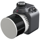
SatLab Apus UAV Lidar based solution

This light compact and superior system integrates an advanced laser scanner with an industrial grade camera and a sophisticated inertial navigation system, is able to collect reliable and great detailed point cloud and rich image information.


Its versatile applications span across 3D spatial data acquisition for terrain mapping, electricity, forestry and agriculture surveys, emergency response, and land planning.

As a robust and intelligent system, Apus excels in most scenes even in the steep, rugged terrain, and thick vegetation.

 Key Features:

  • Data: 1,280,000 points/sec (dual-echo),1,920,000 points/sec (triple-echo)
  • Effective Pixel: 26 Mega Pixel (6252*4168)
  • Lidar Measuring Range:300 m
  • Field of View (FOV):360° (horizontal)*40.3° (vertical)
  • Position Accuracy (pp): Horizontal: 0.01 m; Vertical: 0.02 m
  • Heading Accuracy (pp):0.04°
  • UAVs Designed for DJI M300/DJI M350
  • Lightweight (up to 1Kg)
  • Can capture data autonomously in a designated area
  • Dual storage for data backup